Boundary Surveys
One of the most important services our company provides is the boundary survey. The purpose of a boundary survey is to reestablish and/or recover the property corners of a piece of property and accurately define the limits of the subject property. Property lines are identified on our final survey drawing using a system called "metes and bounds". Bearings accurate to one second of arc and distances to the nearest one hundredth of a foot are calculated for all boundary courses and depicted on our final drawing. The process of determining these boundaries is a very involved process. The outline below details the typical procedure for a boundary survey:
Research:
The first step towards determining the boundaries for a parcel of land involves research. We research many areas, but the most common area of research is the pubic records stored at The Clerk of Superior Court for the applicable county. We will also obtain any right-of-way plans from the Department of Transportation for any adjoining road rights-of-way. Additionally, we will interview the property owner and the adjacent owners for any and all information, including deeds, unrecorded plats, or parole evidence, that may assist us in arriving at our final analysis of the boundary location. We also often rely on information that can be obtained from a title inspection report for the subject property. The title inspection report is usually provided by the client and required if the boundary survey is being done to ALTA/ACSM standards.
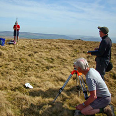
Field Measurements:
After the research is complete, our next step is to visit the site with our equipment and accurately measure the location of all field evidence. We will diligently search for monuments at all property corners. We will look especially hard for monuments that are referenced in our research, as well as for uncalled for monuments.Monuments usually are iron pins, concrete
-
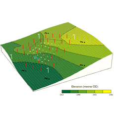
Topographic Surveys
Topographic Surveys are maps depicting the slope of a subject site. We depict the slope of the land utilizing contours These contours are usually shown at a one foot contour interval on our maps. This type of survey is critical for civil engineers to use in designing improvements for a site. All decisions related to the design of the proposed improvement are made utilizing this data. In addition to contours, all other site information is depicted as well, including the location of existing buildings, drives, parking areas, etc. We can make our survey as detailed as the client requests. Some additional items we may include on our topographic survey are tree location and identification, utility location, and wetland location.
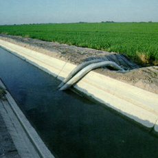
Irrigation Surveys
Geo Surveys has surveyed over 4000 Hectares of Irrigation Projects We possess more than 10 years of experience in Irrigation Projects
Scope Of Services
Macro level first hand survey, planning and investigation for catchments area, hydrogeology, capacity survey and sedimentation analysis Optimisation of submergence area, dam axis and command area Micro level survey, planning and investigation for reservoir limit, dam axis site and main canal alignment Survey, planning and design of main canal and distribution network with minimum cut, fill and length,covering maximum command area Location of structures, full supply level and cut-off statement Field to field survey, fixing of canal network, check limits, alignments and lateral survey Planning of minor, sub-minor, field channels and collector drains, Sourcing of materials, quarry and lead statement Setting out and staking of alignment, apex points, etc.
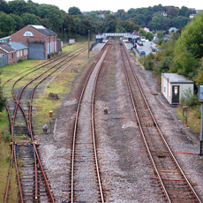
Road Railway Surveys
GeoSurveys has surveyed more than 500 Kms. of Highways Railway Projects Our services range from Survey and Investigation and Design Engineering
Services:Survey and Investigation Design Engineering
Feasibility Study, Survey Control and Setting Out
Data collection, investigation, analysis and economic evaluation to assess viability of highway projects Establishment of highly accurate Planimetric and Height Control network, Electronic Data Acquisition using latest equipment Staking out the designed centerline and marking the same
Traffic, Inventory and Condition Survey
Traffic surveys including classified volume counts,speed-delay, origin-destination, axle load for traffic forecastingPipeline & Tower line
Geo Surveys has surveyed over 200 kms of pipelin tower projects Pipeline routing through difficult terrain having Coastal and Desert features, Wetlands, Evergreen Forests, Western Ghats and Densely Populated Cities
Services:
Reconnaissance and Route OptimisationCenterline and Detailed Route Survey Soil Stratification and Resistivity Survey Investigations for HDD Crossing ROU Acquisition, Permitting and Clearance Reconnaissance and Route Optimisation Desktop study of maps/ satellite imagery identification of pipeline corridor site validation and confirmatory survey Center line survey and establishment of flag control points at definable major crossing locations General appreciation of Terrain, Geology, Soil strata, Land Use, Forest Areas, Land Cost, Weather, Administrative Jurisdiction Related Information For pipeline route optimisation we consider the following points:
Hilly area Industrial Projects
Geo surveys has carried out more than 50 Nos. of Infrastructure Development projects. Geo surveys has surveyed projects in Infrastructure Development Services for Industrial projects, Airports, Roads Highways, Power Plants, Chemical Plants.
Services:
Urban planning as per town planning norms, Land use analysis,Conceptual plan Layout plan, Topographic survey / engineering survey Engineering design of approach roads and internal road network Design of water supply scheme Design of storm water drainage system Preparation of detailed drawings Preparation of detailed project report
-